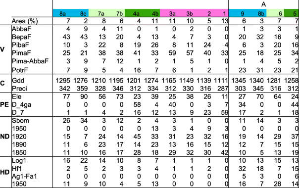
- A: Landscapes of the southern part of the study affected by an increase of Populus tremuloides (PotrF). V: Vegetation: Relative area of Abies balsamea stands (AbbaF), Betula papyrifera (BepaF), Pinus banksiana (PibaF), Picea mariana (PimaF), Picea mariana and Abies balsamea (Pima-AbbaF), Populus tremuloides (PotrF) according to MFFP forest maps (1980s). C: Climate: Annual number of growing degree-days (Gdd), rainfall during the growing season (mm) (Preci) from BioSim software (1971–2000) (Régnière 1996). PE: Physical environment: Absolute difference of topographic elevation (m) between the upper and the lower part of the hills (Ele), relative area of glaciolacustrine fine-textured deposit (clay) (D_4GA) and organic deposits (D_7) according to MFFP forest maps (1980s). ND: Natural disturbances: Relative area for light spruce budworm outbreak from MFFP forest maps (1980s) (Sbom). Relative importance of forest inventory plots classified in relation to fires: before 1870 (1850), between 1870 and 1900 (1890), 1901 and 1930 (1920) and after 1930 (1950). HD: Human disturbances: Relative area covered by logging (Log1), agriculture (Ag1), fallow farmland (Fa1) from MFFP forest maps (1970s). Frequency of human-induced fires per 100 km2 from 1938 to 1998 from MFFP archives (Hf1). Relative importance of forest inventory plots from logging since 1930 (1950)
